Planning Your Route
Google Maps is great for figuring out how to get from one place to another, however if you are time-sensitive, you should not rely on its specific directions. Maps will often suggest fast transfers (from train/bus to train/bus) that cannot be performed by humans or will be made impossible if any delay happens, and some delay almost always happen. If you want to be reasonably conservative, you should assume a fifteen minute headway per-transfer when building your plan (yes, it often is this bad).
In many cases, Google Maps will provide you with several transit options with similar timings. Chicago has an extensive bus system and an extensive rail system coloquially known as the L (or the "El", which is short for "Elevated") so your options will usually involve taking some number of buses and some number of trains. When I first started in Chicago, I would only use the train system because there's always going to be another train at some point and train stations are less exposed structures than bus stops. But there are pros and cons to each. Here are some principles for how I pick routes:
- If I have to choose between a bus-to-train or train-to-bus transfer and a bus-to-bus transfer, I almost always choose the transfer that involves a train. A Bus-to-bus transfer rolls the dice in a number of ways. First, you have to hope the second bus is reliable. Second, you have to hope your first bus makes it in time for a smooth transfer (which is very unpredictable). As a result, bus-to-bus transfers can lead you to hang around an exposed bus-stop in an area you probably aren't very familiar with (after all, you had to take a bus to get there) for an indefinite amount of time.
- If there is an unusually large headway for my bus and the train is an alternative, I take the train (I check this near your time of departure). Buses get much slower as they have to make more stops and a delayed bus or bus with a long headway guarantees someone is going to be waiting at every stop. This creates a feedback loop which can result in the bus ride taking much longer than expected. Trains do not have this issue.
- If I have control over when I start my trip; the bus stop is close by; all else (travel time) is equal, and rule #1+#2 do not apply, I go with the bus over the train. In general, bus rides in Chicago are nicer than train rides and you can avoid hanging out at a bus stop for no reason by starting your walk to the bus so that you arrive only a few minutes before it does.
Actually Doing the Route
Fares for both the L and bus system can be paid for directly by credit card (slightly more expensive) or by the Ventra card (which also handles Metra, a heavy rail line used mainly by suburban commuters) at the turn-style. Credit can be placed on the Ventra card via machine or, more conveniently, by the Ventra App. If you plan to use the L or bus systems once a day, its also more economically to get a monthly unlimited pass.
The Ventra app is also the most obvious / straightforward way to monitor train and bus schedules so you can know the specific timing details of your route. Still, ghost buses can happen. I personally cross-check Ventra's claims with Transit Tracks on Android and other third party apps (e.g. Transit) exist as well. I think whatever app is best is ultimately a matter of superstition. Whatever you choose, I dis-recommend Google Maps for getting times of arrival. It often works but latency / ambiguity about active vs. scheduled buses can make it misleading.
For Ventra specifically, a train/bus is actively moving if green waves show up on the left of its estimated time of arrival. These ETAs have a high but non-guaranteed likelihood of being close-to-accurate. If it doesn't have the green waves, then the time displayed on Ventra is just the time the vehicle is scheduled to arrive and schedules do not mean much in Chicago. If you are near the route's starting point, you cannot depend on the green waves. By the time the bus is activate on the app, you might've missed it. Instead, you have to rely on the schedule and schedule reliability depends on bus route. The more heavily used a bus route is, the more reliable it will be (e.g. the 66 bus tends to be very reliable) because drivers are less likely to be pulled away from it.
Commute Oriented Transit Systems
Looking at a map of Chicago's L System, it seems designed around transporting people into and out of the downtown area, The Loop. It is called the loop, naturally, because this is where the L system loops around. The loop is where the major business districts are located so the system's main function is to facilitate commutes to work and back home. For this purpose, the system works well.
However, being mainly about business, the loop is generally lacking in nightlife — which is more prominent in neighborhoods (e.g. Wicker Park, Lake View are some of the fancier ones). As a result, it is massively easier to meet friends after work if you are both near the same line into the loop or are willing to meet in the loop itself (not ideal compared to meeting in a neighborhood). Thus meetings between people located near different lines tend to be constrained. Buses are an alternative but... people are lazy. Romeo and Juliet are alas separated:
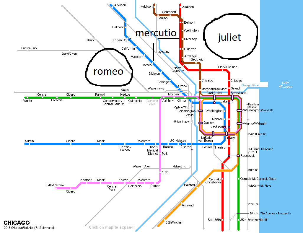
There are options that address this: Mercutio in Bucktown can give up on the L trains completely, and take a bus forty minutes north to Andersonville, 20 minutes east to Lincoln Park, and 10 minutes south to Wicker Park. However, if one is interested really convenient use of the L, it usually makes sense to commit to the red line or the blue line exclusively.
East-West Travel and North-South Travel in North Chicago
While Chicago has a lot of public transit, the L system is designed around access to downtown/the loop. On the North side, one has the red line and the brown-line which both travel along the lake until Irving Park (about as north as Wrigley Field), at which point the Brown line goes west a little bit before ending. The blue-line also exists, traveling roughly North-West at a 45 degree angle, passing through Wicker Park etc but never links up with the brown line. As a result, if you are north of the loop but south of Wrigley Field, you cannot travel East-West via the El. Buses exist, but are not particularly fast, so this means many relatively closely distanced locations in Chicago wind up extremely far away temporally due to differences in access El lines.
An Illustrative Concert
Say I want to go from 1002 N California Ave (a bar in Humboldt) to Metro, 3730 N Clark St to enjoy a Girl in Red concert at 7PM. I can take the 65, 66 or 70 bus to the Red Line, or take the 94 bus to the 152 bus. Each of these routes take between 57 and 59 minutes.
Now say I want to do the same thing from the North suburbs, starting at the Lake Cook Rd Metra Stop and going to the same place. I can take the MD-N to 80 bus or to the 152 bus. This takes 1 hr and 19-22 minutes. Despite almost quadrupling the distance from the city, the travel time has only increased 30%.
This gets even worse if one aims further North in Chicago. 1002 N California Ave to Andersonville works via th 66 or 70 bus to the 50 bus, taking 1 hr and 9-11 minutes. From the Lake Cook Metra, one can simply take the MD-N to the 92 bus in 1 hr and 24 minutes. For this purpose, living in Humboldt Park vs living in the suburbs constitutes a 15 minute change in commute.
To be fair, this demands on Suburban proximity to a train station. But, in my experience, getting to a station isn't very hard. This also isn't even the worst-case scenario. Imagine, instead of living in the suburbs, that you're a student at Northwestern University just getting out of the Tech Building. You walk to the purple line stop, ride it to the red line stop, and then walk in, taking 46 minutes total. Despite being roughly twice as far away from the destination, a Northwestern student can arrive to the concert ten minutes before a Chicago resident in Humboldt.